Vancouver, BC– Summa Silver Corp (“Summa Silver” or the “Company”)(CSE: SSVR, OTCQB: SSVRF, Frankfurt: 48X)is pleased to report the results from two geophysical surveys at its Hughes Property, near Tonopah Nevada.
Key Highlights
- First-Ever Exploration using Geophysics: Covering the unexplored hydrothermal alteration zones present on the eastern half of the property, these surveys are the first-ever known to have been done on the property, which consists of the eastern half of the historic Tonopah Mining District and its extension.
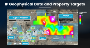
- Un-Drilled High Priority Targets: Numerous targets are defined which will be ranked and systematically evaluated by geological and structural mapping and as well as soil geochemical surveys which are now in progress (see attached figures).
- IP – Resistivity Surveys: 42 line kilometers of both 3D and 2D induced polarization (IP) and resistivity data were collected to identify zones of alteration at depth which may be associated with high-grade silver and gold mineralization.
- Drone-Magnetic Survey: 330 line kilometres of drone-based, high-resolution magnetic data were collected to refine the property-scale structural model.
- Core Drilling Update: The previously announced 10,000 m drill program is well underway with 10 holes completed. Two core rigs are fully operational on the project. All holes have intersected zones of quartz veins, stockworks and breccias featuring visible silver-sulfosalt minerals, which is often a strong indication that the core is mineralized. Upon receipt of assays, the results will be compiled and announced in a timely manner.
Galen McNamara, CEO, stated: “The presence of multiple, major and compelling targets that not only remain completely unexplored but also occur in the shadow of one of the richest silver districts in the United States in an exciting development. We look forward to integrating these new targets with geological and soil surveys that are now in progress as we advance them towards the drilling stage in the near future.”
Geophysical Surveys
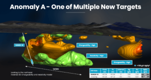
Based on an interpretation of the high-resolution magnetics data, several key faults are identified (e.g., Mizpah, Belmont, Halifax and Ruby) as well as new, previously unrecognized parallel-striking faults and structural intersections. These prospective northwest-trending faults transect the property and cross-cut Mizpah Formation volcanic rocks; host to high-grade silver and gold bearing veins throughout the district. The IP and resistivity data further outlined numerous coincident high-chargeability and high-resistivity features spatially related to these northwest-trending structures. These anomalies are interpreted to be structurally controlled silica alteration zones host to possible sulfide mineralization. One immediate target of interest (Anomaly A; Figures 1 and 2) is centred 500 metres east of the Ruby discovery where limited drilling has intersected broad zones of silica + clay alteration with local vein-hosted silver and gold mineralization in SUM20-10 (see News Release dated December 17th, 2020). This coincident broad high-chargeability and high-resistivity anomaly as well as anomalies B through D will be further investigated with detailed geological and soil geochemical surveys and possible exploration drilling.
Magnetics Survey
A property-wide drone-based magnetic geophysical survey was conducted by Pioneer Exploration Consultants Ltd. of Saskatoon, Canada (see News Release dated December 17th, 2020). The survey footprint covered the entire Hughes property and consisted of 330 line kilometers at an average height of ~35 metres above ground. Lines consisted of 50 metre spaced north-south oriented lines and 100 metre spaced east-west oriented lines. The purpose of the survey was to provide insights into the orientation and strike-extent of near-surface, property-scale structures.
Induced Polarization Survey
Over 3 km2 of 3D IP data and over 21 line kilometres of conventional 2D dipole-dipole data were acquired by SJ Geophysics of Langley, Canada. Thirteen north-south oriented, 150 metre spaced lines comprised the 3D grid and 6 east-west oriented, 400 metre spaced lines and 3 north-south oriented lines comprised the 2D survey. The goal of both surveys was to investigate the mineralization potential of recently identified property-scale structures. High-chargeability anomalies are interpreted to represent zones of high-sulfide content, likely disseminated, as these minerals and textures may generate a strong IP-effect.
Qualified Person
The technical content of this news release has been reviewed and approved by Galen McNamara, P. Geo., the CEO of the Company and a qualified person as defined by National Instrument 43-101.
About Summa Silver Corp
Summa Silver Corp is a Canadian junior mineral exploration company. The Company has options to earn 100% interests in the Hughes property located in central Nevada and the Mogollon property located in southwestern New Mexico. The Hughes property is host to the high-grade past-producing Belmont Mine, one of the most prolific silver producers in the United States between 1903 and 1929. The mine has remained inactive since commercial production ceased in 1929 due to heavily depressed metal prices and little to no modern exploration work has ever been completed.
Follow us on Twitter & LinkedIn
Investor Relations
Kin Communications
604 684 6730
SSVR@kincommunications.com
Neither the TSX Venture Exchange nor its Regulation Services Provider (as that term is defined in the policies of the TSX Venture Exchange) accepts responsibility for the adequacy or accuracy of this release.
Cautionary note regarding forward-looking statements
This news release contains certain “forward looking statements” and certain “forward-looking information” as defined under applicable Canadian and U.S. securities laws. Forward-looking statements and information can generally be identified by the use of forward-looking terminology such as “may”, “will”, “should”, “expect”, “intend”, “estimate”, “anticipate”, “believe”, “continue”, “plans” or similar terminology. The forward-looking information contained herein is provided for the purpose of assisting readers in understanding management’s current expectations and plans relating to the future. These forward‐looking statements or information relate to, among other things: the release of assays, and the exploration and development of the Company’s mineral exploration projects including completion of surveys and drilling activities.
Forward-looking information is subject to known and unknown risks, uncertainties and other factors that may cause the actual actions, events or results to be materially different from those expressed or implied by such forward-looking information, including but not limited to: the requirement for regulatory approvals; enhanced uncertainty in global financial markets as a result of the current COVID-19 pandemic; unquantifiable risks related to government actions and interventions; stock market volatility; regulatory restrictions; and other related risks and uncertainties.
Forward-looking information are based on management of the parties’ reasonable assumptions, estimates, expectations, analyses and opinions, which are based on such management’s experience and perception of trends, current conditions and expected developments, and other factors that management believes are relevant and reasonable in the circumstances, but which may prove to be incorrect.
The Company undertakes no obligation to update forward-looking information except as required by applicable law. Such forward-looking information represents management’s best judgment based on information currently available. No forward-looking statement can be guaranteed and actual future results may vary materially. Accordingly, readers are advised not to place undue reliance on forward-looking statements or information.


